
The Easter weekend is upon us, and many South Africans will be travelling to their respective destinations. Most will also be attending religious gatherings at various churches across the country. Below is a summary of the expected weather conditions for the long weekend.
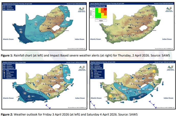
An upper-air trough is expected to make landfall over the south-western parts of the country on Thursday, 2 April 2026, bringing scattered showers and thundershowers to the Western Cape and Northern Cape (Figure 1). As this system moves eastwards, scattered showers will shift to the Eastern Cape by Saturday, while conditions will begin to clear over the Western Cape and Northern Cape (Figure 2).
By Sunday, the system is expected to exit the country, with KwaZulu-Natal likely to experience scattered showers and thundershowers on Sunday and Monday (Figure 3).
The central and northern parts of the country can expect a continuation of typical autumn weather in the days ahead, in particular, partly cloudy and cool to warm conditions, with isolated afternoon showers and thundershowers at times.
No significant weather warnings have been issued at this stage. However, the South African Weather Service will continue to monitor conditions closely and will issue warnings if necessary.
Compiled by: Tokelo Chiloane
Edited by: Kevin Rae
Approved by: Rudzani Malala
For technical and weather enquiries:
National Forecasting Centre: Tel: 012 367 6041